In June 2013, the Bow and Elbow rivers crested at levels not seen in a century. Thirty-two communities were affected. Over 75,000 Calgarians were evacuated. Neighbourhoods like Sunnyside, Inglewood, Erlton, Stampede Park, and the Elbow River corridor sustained significant damage. Whole blocks that had been family homes for generations were under metres of water.
The 2013 floods changed something in how Calgary thinks about building near rivers. They also changed how architects, engineers, and the City of Calgary approach residential construction in flood-affected areas. More than a decade later, that shift is still working its way through policy, design practice, and the decisions of individual homeowners. This is what we learned — and what it means if you are building or rebuilding in one of Calgary's river communities today.
The regulatory landscape after 2013
The floods prompted the Province of Alberta to significantly revise its floodplain mapping and associated development controls. Alberta Environment published updated flood hazard maps for the Bow and Elbow rivers, and the City of Calgary updated its Land Use Bylaw to reflect tighter restrictions on development within flood-affected areas. Two key designations govern most of the affected communities:
- Floodway (FW): The channel of the river and the adjacent land required to convey the design flood flow. Development within the floodway is severely restricted. In most cases, new residential construction is not permitted, and significant renovations to existing buildings face strict constraints. If your property is in the floodway, the options available to you are limited and require careful professional assessment.
- Flood Fringe (FF): The area outside the floodway that would be inundated during a design flood event, but where flood depths and velocities are lower. New construction and major renovation in the flood fringe is generally permitted in Calgary, subject to minimum flood-proofing requirements. This is where most flood-zone residential projects in Calgary actually occur.
It is important to confirm which designation applies to a specific property before committing to a project. The mapping has been updated since 2013, and some properties that were previously undesignated have been added to flood fringe areas. Calgary's Development Services can confirm the applicable flood overlay for a given address.
Flood maps are point-in-time documents. The river doesn't read them. Design to a higher standard than the minimum, and you will sleep better during June.
What the 2013 floods taught us about how homes fail
The most instructive dimension of the 2013 disaster, from an architectural standpoint, was the failure pattern of homes that were inundated. Several lessons emerged clearly from the recovery and rebuilding work that followed:
Finished basements were the single greatest source of loss. Homes where the primary living space was below grade — rec rooms, bedrooms, home offices, secondary suites — suffered the most severe financial and practical damage. Water entered rapidly and the finished assembly absorbed it. Rebuilding a finished basement after flood damage is expensive, disruptive, and, in most flood fringe areas, requires flood-proofing that the original construction never incorporated.
Mechanical and electrical systems located at grade or below were vulnerable. Furnaces, hot water heaters, electrical panels, and sump systems that sat at or below the flood level were destroyed. Relocating these systems to an upper floor — or at minimum to a platform elevated above the design flood elevation — is one of the most cost-effective flood mitigation measures available in new construction.
Flood entry pathways were often surprising. Water did not only come through doors and windows. It entered through foundation wall cracks, sewer backflow, window well drainage failures, and weeping tile that became overwhelmed and reversed. Buildings designed with flood awareness address each of these pathways deliberately, not as afterthoughts.
Material choices determined recovery time. Homes built with water-tolerant materials — polished concrete floors, masonry walls, tile finishes — recovered dramatically faster than homes with wood subfloors, drywall, and carpet. The distinction between materials that can be dried and reused versus materials that must be stripped and replaced after inundation has real consequences for how quickly a home can return to habitability.
Flood-resilient design: what it actually means in practice
Flood-resilient residential design is not a single intervention. It is a set of decisions made across the design process that, taken together, significantly reduce the consequences of a flood event. The key design moves for Calgary river community homes include:
- Finished floor elevation. The minimum finished floor elevation for new construction in Calgary's flood fringe is set by the applicable Land Use Bylaw overlay and is typically referenced to the design flood level plus a freeboard margin. In practice, many architects designing for flood-aware clients recommend finishing slightly higher than the regulatory minimum, as the cost difference is marginal and the added buffer has real value.
- Foundation type and strategy. Slab-on-grade or crawlspace foundations can be designed with flood resilience more readily than full basements. Where a basement is desired or required by program, flood-proofing measures including membrane waterproofing, backflow prevention, and sump redundancy become critical.
- Backflow prevention. Sewer backflow during a flood event is one of the most damaging and underappreciated failure modes. A properly specified and maintained backflow prevention valve on the main sewer connection is a relatively low-cost measure that can prevent significant damage.
- Mechanical and electrical elevation. Locating the furnace, hot water system, and main electrical panel above the design flood elevation is one of the highest-value flood mitigation measures in new construction. It is straightforward to design for in a new home and much more disruptive to retrofit.
- Material selection through a flood lens. Concrete, tile, stone, and treated masonry are flood-tolerant. Wood structural systems, OSB sheathing, fibreglass batt insulation, and paper-faced drywall are not. A home designed with the awareness that water may one day enter it selects materials accordingly — at least in the most vulnerable zones of the building.
- Window and door detailing. Flood-rated windows and doors are available and should be considered for openings below the design flood elevation. At minimum, window wells should have proper drainage capacity and protection against blockage.
The insurance dimension
The 2013 floods exposed a significant gap in Canadian residential insurance coverage: most standard home insurance policies at the time did not cover overland flooding, only sewer backup. The insurance industry has responded by introducing overland flood coverage as an add-on or endorsement in most markets, including Alberta. However, properties within designated flood hazard areas may face coverage limitations, higher premiums, or exclusions that reflect their risk profile.
Before purchasing or building in a Calgary flood fringe area, it is worth having a detailed conversation with an insurance broker about what coverage will actually be available for the finished home, and under what conditions claims would be paid or denied. This is not an architectural question, but it is a project planning question that has significant bearing on whether a particular flood-zone site is the right fit for your household.
The design opportunity in constraint
There is something easy to miss in all of this: flood-affected sites in Calgary are often among the most beautiful. The Bow and Elbow river corridors have mature trees, river views, proximity to pathways and park networks, and a physical relationship to the landscape that inner-city blocks away from the water simply don't offer. Communities like Sunnyside, Inglewood, Rideau, and Riverdale have a particular urban character shaped in part by their proximity to the river. The constraint of building near water is also the source of the value.
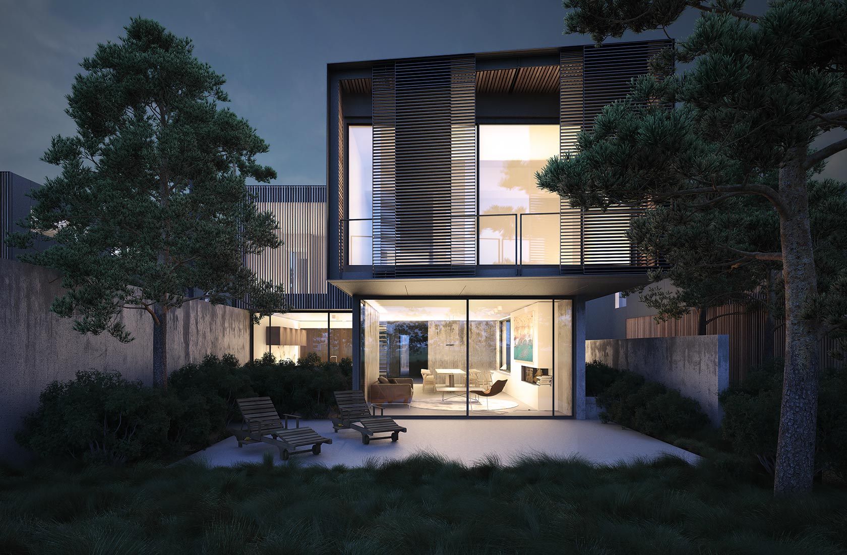
Designing well for these sites is not about defeating the flood risk. It is about understanding the river as a design partner — something the building must acknowledge, accommodate, and in the best cases, make visible as part of the home's character. Elevated main floors become opportunities for living rooms with elevated views. Flood-tolerant ground-floor programs — garages, mud rooms, utility spaces — free the upper levels for the primary living areas. Material honesty at grade, where resilience matters most, often produces the most interesting architectural expressions.
The Riverdale project in our portfolio is a direct engagement with these conditions: a home designed for a site with flood fringe overlay, where every major decision — from floor elevation to material palette to the orientation of primary living spaces — was shaped by the site's relationship to the Bow River.
What to ask before buying or building on a flood-zone site
If you are considering a site in or near one of Calgary's river communities, these are the questions to have answered before you commit:
- What is the specific flood designation — floodway or flood fringe? Have you confirmed this with the City rather than relying on general maps?
- What is the minimum finished floor elevation required by the Land Use Bylaw overlay for this property?
- Has the site been affected in previous flood events? What happened, and what mitigation, if any, was done afterward?
- What overland flood insurance coverage is available for the finished home, and are there limitations or exclusions specific to the flood hazard designation?
- Does the architect you are considering have experience designing in flood fringe conditions specifically?
None of these questions should deter you from building in Calgary's river communities. They should inform how you build — and ensure that the home you create can hold its place beside the river for the long term, through whatever the Bow and Elbow eventually bring.